Monday, March 31, 2014

Traveling and photographing of East Coast of USA

We travelled to east coast at different seasons, to see the fall foliage of north east and to escape winter to south east. Each with wonderful experience. The north east is well known for its fall colors during autumn. This is probably the best region with well defined four seasons. However, my favorite season is fall. The fall color is at its best along Kancamagus highway through the white mountains of New Hampshire. Kancamagus drive is a designated All American road between Conway in New Hampshire and Lincoln in Vermont. The best fall foliage occurs during the window of one week before and one week after the Columbus day weekend. Except blue color, every color can be seen on the leaves. Acadia National Park in Maine, Kancamagus highway, Lake Winnipesaukee and Merrimack river provides the best of New England fall foliage. Avoid interstate to travel between these locations. Instead, take small roads through small towns with white steepled churches and village barns provide the best of New England charm.
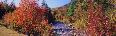
The Swift river along Kancamagus highway in white mountains of New Hampshire.

Boston - Acadia N.P - Kancamagus Highway- Lake Winnipesaukee - Merrimack River- Boston loop

As a norm, we always travel in a loop so that we do not have to visit the place we already visited. We always visit Wayside inn which is located in the Boston suburb of Marlborough. This is a grist mill surrounded by spectacular fall foliage. The peak fall colors here observed around Columbus day weekend. For going to Acadia NP, we take interstate 95 north to Augusta (Capital of Maine) and exit to route 3 east to Belfast and route 1 and then route 3 south to all the way to Acadia National Park. We found the national park little rockier than forested. However, the ever present fog, the foliage and rough Atlantic coast with couple of blow holes provide an unusual combination. Acadia is the northern end of Appalachian trail. The park is extremely crowded during fall season. The best of the trip is the trekking to Jordan pond, thunder hole and wonderland.


Connecticut river

From Acadia, take route 95 south and exit to state routes passing through towns like Poland and Denmark to reach Conway. From Conway, the route 112 - Kancamagus highway begins. There is a beautiful covered bridge in Conway. This is a 34 mile highway which is considered the most beautiful during fall in all of USA. The peak fall foliage is around the Columbus day weekend. This may shift one week before of after the Columbus day weekend depending on the weather conditions. The other end of the Kancamagus highway is the town of Lincoln in Vermont.


Niagara in Summer

From Lincoln, interstate 93 winds along Merrimack river with plenty of view points state parks on the way. Take exit to lake Winnipesaukee. We took a round trip cruise in the lake with dinner and music. In the evening, we returned to Boston via Concord and Manchester on 95 south.

Niagara in Fall

New York city and Niagara,
There are lot of places to see in New York city, from Broadway musicals to Wall street to empire state building. We visit these places just for the sake of visiting. We enjoy seeing New York city from a distance - from the Liberty State park or Ellis Island. Visiting New York is not complete without visiting Statue of liberty. Those who are interested in genealogy, visiting Ellis Island is also a necessity.

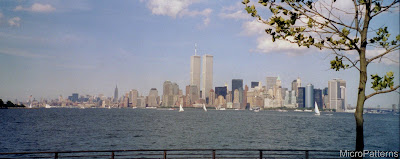
NewYork skyline, once upon a time.

Visit to east coast is not complete without visiting Niagara falls. You can access Niagara from both from US and Canadian sides. Canadian side provides a frontal view of the Falls. However, the falling water creates enough mist to obstruct the view. Unfortunately, all through my visits each spending couple of days, I never got a clear view from the Canadian side. Always carry a jacket even in peak summer while visiting falls, especially during the evenings. The evaporating mist makes the entire area very cold. My favorite time to visit Niagara is on a warm day during Fall season. The visit to Niagara is not complete with out the Maid of the mist boat ride to the bottom of the Falls. The best time to see the awesome power of water is during Spring time when the volume of water falls is maximum due to snow melt.
Tidal Basin during cherry blossom, Jefferson Memorial, Washington DC,


Tidal Basin in winter wonderland, Jefferson Memorial, Washington DC,

Apart from the Political landmarks (White house, capitol) and memorials (Washington, Jefferson, Lincoln, Roosevelt, Vietnam, etc.) and museums (American Indian, Natural history, Modern art, air and space etc.) my favorite is tidal basin during Cherry blossom. Usually the peak bloom time is last week of March and first week of April. However, depending on weather conditions, it may arrive one week early or one week late. The tidal basin area will be extremely crowded during these time. Parking is no longer allowed near the tidal basin area. So visitors need to take shuttle buses.


Tidal Basin during cherry blossom, Washington Memorial, Washington DC,

Shenandoah National Park and Laurey Caverns

Compared to other national parks, there is nothing special about Shenandoah national park except its trekking trails. Southern side of Shenandoah (close to Blue ridge parkway), there are a number of trails winding through waterfalls and meadows. My favorite time to visit Shenandoah (apart from summer trekking ) are third week of May and third week of October. Rhododendron and wild flowers bloom during the last week of May. Last week of October is peak time for fall foliage. Shenandoah is closed during winter. Approximately, in the middle of the Shenandoah and just out side of it is Laurey Caverns. It is the most beautiful and visited cave in the eastern USA. Unlike other cave systems, the stalagmites and stalactites are extremely beautiful here.

Blue ridge Parkway, Smokey Mountain National Park,
Blue ridge parkway is situated between Shenandoah and Smokey Mountain National Parks along the Appalachian mountains. This parkway is considered one of the ten most scenic drives in USA. My favorite landmarks along blue ridge are Mabry grist mill, Linville water falls and Linn cove viaduct. Trekking to lower and higher Linville water falls during fall is extremely beautiful. Like Shenandoah, Blue Ridge parkway is open through except during winter. However, the best time during 3rd week of May when wild flowers bloom and 3rd week of October when fall foliage is at its peak. The best part of Blue Ridge Parkway is between Asheville, NC and Gatlinburg, TN because of numerous tunnels along the way. Tunnels take you to other side of the ridge with different fall foliage. Blue ridge parkway runs parallel to Interstate -80.


South of Blue Ridge parkway is the Smokey Mountain National Park. This is the most visited national park in USA due to its proximity to big cities around it. This means, lot of crowd and bumper to bumper traffic especially during fall and summer holidays. We always avoid eastern entrance (Gatlinburg, TN) and enter the park from the western entrance (Cherokee, Asheville or Maggie Valley of NC).


State Parks of West Virginia.

There are a number of beautiful state parks in the wild and wonderful state of West Virginia. We like Blackwater river falls, Babcock and Hawks Nest the most. The latter two are in the New river Gorge area. The best time to visit these places is the fall season.


The grist mill in Babcock is one of the most beautiful grist mill in all of USA. This grist mill is one of the most photographed landmark in USA. Babcock state park is very close to New River gorge recreational area.


Western hemisphere's largest single span bridge is located here. During Fall, on Bridge day, many people jump from the bridge (umm.. with parachute). New river is well known for white water rafting.


Blackwater river fall in Autumn

 
Falling Water
 
The Falling Water is the most famous masterpiece of renowned architect Frank Lloyd right. This is located in a small town called Mill Run in Pennsylvania. This is about 3 and half hours drive from Washington DC. The best time to visit Falling Water is either late Spring when Rhododendron blooms or during fall around third week of October. We went on the third weekend of October,2012 and the fall colors were at its peak. We followed interstate 270 west, 70 west, 68 West and took state routes 40 and 381 north. We stayed in a small town called Chalk hill. Nearby, there is state park called Ohio Pyle state park which is well known for whitewater rafting, bike trails and trekking. Frank Lloyd Wright's another masterpiece, Kentuck Knob is also located very close by.


Traveling and Photographing Yellowstone National Park


Grand Prismatic Geyser, Yellowstone National Park, WY


It was a childhood dream to visit Yellow stone national park. When we got the first opportunity to visit, we thought of making use of it. We tried to combine visiting Yellow stone, Grand Teton, Glacial National park and the Devils Tower national monument. However, after some assessment we decided to to let Glacial and Devils Tower go due to lack of time. Now it is time to figure out where to fly in. Most of the airports in and around Yellow stone are small and expensive. Out of the two biggest, Denver and Salt Lake city, we chose salt lake city as it less expensive and closer to yellow stone NP. However, it was 5 hours drive due north on Interstate 15 and route 20 north.

Lower Falls, Yellowstone National Park, WY


In order to reach faster, we took a short cut from the town of Ashton and Maryville, ID to Grand Teton National Park. Although it is only around 60 miles on the map, it was a unpaved forest road. Our Ford Taurus was not that equipped to navigate fast on that road. With absolute zero traffic, no directions, not even a compass it took around 6 hours to figure out it as not a short cut after all. However, it was a great adventure to start the vacation with.


Morning Glory Geyser, Yellowstone National Park, WY


Yellow stone is nature at its best. There are plenty of things to enjoy and learn. The roads around the park is in the form of number '8', one upper northern loop and one lower southern loop. There are roads connecting the neighboring towns to this loop. This first national park in the world probably is the only place where you can see nature's wonders just around you- water falls, many types of geysers, wild life, meadows, canyons, mountains and lakes and so on. The meadows along the road from West Yellowstone, MT to Madsion is excellent for wildlife viewing.


Steam Boat Geyser, Yellowstone National Park, WY


If you connect all the water falls in the Yellow stone in a map, you will get a circle. Why? Yellow stone is a collapsed volcano with semi-active caldera which is in the form of a circle. The rocks outside caldera is more erodible than inside. So the waterfalls are along the caldera rim.

Mt Moran, Grand Teton National Park, WY


Most of the geysers are concentrated along the lower loop road. This loop approximately border the caldera boundary, the waterfalls and geysers are easily accessible from the lower loop road. There are geysers of every type and sizes. However, grand prismatic is the most beautiful and Old faithful is the most majestic. The prismatic got its name from its color. Depending on the temperature, different types of bacteria and micro organisms grow in those water. Different types of these organisms produce different colors in circular contours. Although many geysers erupts in the park, the impeccable time keeping of Old faithful makes it majestic.

Mt. Moran from Signal Mountain, Grand Teton National Park, WY


Now a days it is very rare to encounter the most famous face of Yellow stone- Grizzly. As soon as the homosapiens invaded the park, these majestic creatures withdrawn to the park interiors. Of all the water falls, the lower yellow stone fall is the biggest. It is almost twice as tall as Niagara. Two best place to view wild life in the park are Hayden and Lamar valleys. Lamar valley is on route 212, east of which is a designated National Scenic Byway (NSB) leading to Bear tooth mountains. Once almost extinct Buffaloes(Bison) are seen every where. It seems they have a long memory (of what we did to them) ,so keep your distance. Minimum one week is required to enjoy every aspects of Yellow stone national park.

Grand Teton National Park, WY


Why Snake river drains to Pacific while Yellowstone river drains to Atlantic while both originate from this park? This is because the continental divide split the Yellow stone national park into two halves. The northern catchment drains to Yellow stone river while southern catchment drains to Snake river.

Just 50 miles south of Yellow stone is Grand Teton National park. Some say this is the most beautiful national park in the contiguous US. Some of the Ansel Adam's best photographs are taken in this park. The view of Teton range across Jackson lake from Signal mountain is breath taking, especially the sunset. Never ever miss this if you ever visit Grand Tetons. Go early, otherwise you end up elbowing with professional photographers.

Grand Teton National Park, WY


We had our most memorable moment here. While waiting to see the sun set behind the mount Moran, we saw a pony tailed native American climb a rock nearby, spreading his hand and telling to his children - "Once this was our sacred land".


Keys points to remember

1) Not all short cuts are short: Don't' rely on the maps alone. It will not show the conditions of the road
.
2) Need at least 5 days explore and enjoy both Yellow stone and Grand Tetons. With kids, you need 7 days.
3) Carry a light jacket even in summer. Katabatic winds from mountain glaciers make evenings cold
4) Fill the gas tank even if it is 3/4 full whenever you pass small towns. Gas price is very expensive inside the park.
5) Never miss sunset from Signal Mountain. Have a lunch or early dinner at Signal Mountain Lodge restaurant. The view of the Teton range from here is breathtaking.
6) Drive very slow and carefully during dusk and dawn. Animals are everywhere.
7) Have sunscreen handy. Beach is not the only place you will get burned.


Grand Teton National Park, WY

Traveling and Photograhing Pacific coast of USA


Lake Tahoe, CA


As usual, once we decided on a vacation spot we looked around for the major airports around the vacation spots. This time we decided to visit California. The major airports are Los Angeles, Oakland, San Francisco and Sacramento. After comparing the flight expense, rental car and routes to take, we decided on Sacramento. This time also we took a loop around the vacation spots, arrival and departure at Sacramento airport. Our first destination was Lake Tahoe. For this, we took route 50 west through Eldorado National forest. This was really an uphill drive almost up to Lake Tahoe. There are lot of beautiful over looks on the way. We took a complete loop around the lake Tahoe. There are plenty of beautiful over looks to the lake. Lake Tahoe is the highest and largest Alpine lake in US. The eastern shore of Lake Tahoe is designated as National Scenic-byway(NSB).

Yesomite National Park, CA


Why is Lake Tahoe so bluish? Because of the depth, clarity of water and the prevalent clear blue skies. Lake Tahoe is the third deepest lake (after Crater lake of Oregon and great Slave lake of Canada). Most of precipitation falls directly on the lake and the run off to the lake from streams are filtered off by meadows and forests around it. Unfortunately, this is changing due to rapid development around the lake.

Yesomite National Park, CA


The next destination was Yosemite National Park. We took route 89 south and then 395 south to reach Lee Vining. There is a salt lake in Lee Vining called Mono Lake which has plenty of salt rocks on its shore. This is a sad story of how water diverted for agriculture can destroy a beautiful lake. From Lee Vining, route 120 also called Tioga Pass road takes across Sierra Nevada plateau and to the western edge of Yosemite National Park. This is a national scenic Byway. This scenic route wades through lakes, meadows and snow capped mountains. Tuolumne meadows is a popular recreational area on the way. Apart from taking a drive around the Yosemite valley surrounded by El capitan, half dome and water falls, had a picnic on the banks of Mecerd river and trekked to Nevada falls. Being acrophobic prevented going beyond Nevada falls and carrying tripod and camera gears was too strenuous. Glacial point drive gave a panoramic view of the Yosemite valley.

Yesomite National Park, CA


What is the difference between National Scenic byway and All American roads? A National Scenic byway designated by US department of transportation for its historical, cultural, natural, scenic, archaeological and recreational importance. The most scenic among them are designated as All American roads, which means they have features that do not exist anywhere else in USA.

Yesomite National Park, CA


It is time to give El Capitan a parting salute and march towards Kings Canyon National Park. Kings canyon National park and Sequoia national parks are like twin parks, adjacent and covered with Sequoia forests. Giant sequoia trees is the biggest living organism on earth. We took route 41 south to Fresno and 180 east and then route 198 which is appropriately named General's Highway. As our SUV snaked through the General's highway dwarfed by giant Sequoia trees, we encountered a number of black bear families on the road with all sows radio collared. We no longer let them roam free without eavesdropping in their lives!!. Compared to Yosemite, these parks are virtually deserted. Of all the time we spent in front of General Sherman, we could not find any other human being. May be it is what it is meant to be.

Yesomite National Park, CA


No more small roads to Bay area. We took Route 198 west, 99 North, 589 west and 680 north to reach Bay area. The panoramic night view of bay area across Golden Gate bridge from Golden gate recreational area was breath taking. Now it is a long way to Red Wood national park along route 101 north. Red woods are tallest trees on earth. Like sequoia, barks of redwood is fire resistant make it survive forest fires and lightning. There are multiple groves of red woods along the pacific coast. Redwoods are commonly photographed with the coastal fog created by California current. There are plenty of well established trekking trails in the park.

Yesomite National Park, CA


What is the difference between Redwood and Sequoia? Redwood grows along rainy coastal area while Sequoia grows drier inland especially on the western slopes of Sierra Nevada. Redwood is taller while Sequoia is fatter. Sequoia is not good for lumber while redwood is good for lumber. Now you know that Sequoia has a future!!

General Sherman, Sequoia National Park, CA


Tired of looking up for a long time, it is time to head north to look down at Crater Lake National Park. We took route 199 North, 5 east and 62 north (also called Crater lake highway) to reach Crater Lake National Park. It is the deepest lake in north America. Because of this, it's water is warm even in winter and the resulting lake effect dump lot of snow on its surrounding area. Due to snow, the loop road around the crater usually open only late June. There are plenty of overlooks around the loop road. The route 62 south towards Klamouth Falls, route 97 south, interstate 5 south and route 89 south are designated NSBs. The extinct volcano Mount Shasta is situated beside interstate 5. On a clear day, mount Shasta can be visible from very far away as it is the second tallest volcano in US.

Mouth of Klamouth river, Redwood National Park, CA


On the route to Lassen Peak Volcanic peak national Park is Burney falls state Park. This is an unusual water fall where the water falls from different levels through the fissures in the rock. Lassen peak is also an extinct volcano comprise of geysers, mud flats and boiling mud. Snow capped Lassen peak and surrounding lakes such as Reflection and Manzanita are extremely beautiful to photograph. Due to the presence of late snows, this park also open late like Crater lake national Park. Unfortunately, I lost the entire roll I took at Lassen Peak due to a small mistake in rewinding the film. This happens!!. Now it is time to head back to Sacramento and to home. We took 44 west and then to interstate 5 south to Sacramento.

Redwood National Park, CA


Key Points to remember
a) When you choose routes, avoid interstate as much as possible. Of course you reach your destination faster, but you miss the wonders offered by small country roads. Always try to incorporate All American roads and National Scenic byways in your planned route.

b) When traveling in remote and rural roads, keep considerable distance with the vehicle ahead. We had a very bad experience in Grand Canyon North rim. Tires trap small stones in their grooves and fire it shattering the wind shields.

Redwood National Park, CA


c) Keep half day of every 3rd day for catching up in long vacations. It may be catching up your sleep or drive. How well you prepare and pre-plan, there may be something which make your trip delay, may be a traffic jam or you want to meet somebody. So Keep half day of every 3rd day for this.

d) If you feel tired or sleepy during long trips, just pull over immediately or hand over the steering to you spouse. It is just not worth the risk.


Crater Lake National Park, OR


Equipment Used: Pentax SLR ZX-5N with lens SMC -FA 1:2 24 mm IF & AL and Pentax circular polarizer

Photographing South West Desert of USA

This is about our 2 weeks vacation traveling and photographing desert south west of USA.


Antelope Canyon, Page, AZ


There are 5 major airports surrounding the South west. They are Los Angeles, CA, Boulder, CO, Salt Lake city, UT, Las Vegas, NV and Phoenix, AZ. Rental cars/RV and flights are much cheaper in such major airports. Use the same airport for both arrival and departure to keep flight expenses low. We found that Phoenix provided the best value with respect to SUV rental, flight expense and was closer to our vacation spots. RVing (Recreational Vehicle) is the best way to do your vacation. It will take care of your accommodation, travel and food. RV provides best value for your vacation per dollar. You do not have to hunt for restaurants in the middle of nowhere. It is just behind you. You can pull over the best spot for the night. Depending on the size of the RV, you need to visit the dump station and refilling the water tank every 2 or 3 days. However, most the the RV rental companies do not allow off the road travel. Because of this reason we opted for a medium sized SUV. Three most important advantages of SUV are, the ability to sit upright for long travel, lot of luggage space for travel gear and for off-road travel. Always plan the vacation routes in a circular manner starting with point of arrival and ending with point of departure. Thus, you do not have to visit the places you already visited.


Court of the Patriarchs, Zion National Park, UT


We started from Phoenix to Las vegas via route 93 called Joshua tree parkway, Part of it is interstate 40. As the name suggests, there are plenty of Joshua trees on the way. We spent some time exploring Hoover dam and Lake Mead. Hoover dam is an arch dam. Two days we spent on Las Vegas was worst part of our trip. We realized that we are not glitter loving gambling enthusiasts. Our next destination was Zion national park. Instead of taking interstate 15, we took the North shore road(route 167) along the lake Mead. The Valley of Fire state park, NV is easily accessible from this road by route 169. This is Nevada's first state park. Located in the confluence of Virgin and Colorado rivers, this state park provides what a typical desert biome has to offer. Route 169 between interstate 15 and route 167 is designated as a scenic route. There are trekking trails, petroglyphs of Pueblo and Anasazi Indians, slot canyons, desert vistas, colorful and intricately shaped rocks and arches.


Zion National Park, UT

Do you know? In gravity dam, the water pressure of the reservoir is compensated by the weight of the dam. Higher the level of the reservoir, heavier the dam is. On the other hand, in arch dam, the water pressure is distributed to the both canyon walls. So arch dam is very thin compared to gravity dam.

Do you know difference between Joshua tree and Saguaro? Both are common in North American deserts. Joshua is tree mostly found in and around Mojave desert. Saguaro is a cactus fond mostly in and around Sonoran desert.


Point Imperial, Grand Canyon National Park (North Rim), AZ


Take Interstate 15 north to enter Utah. After passing cities like Mesquite and st. George take exit to route 9 to proceed to Zion National park. Zion is Utah's first national park. Parking is very limited inside the park and private vehicles are not allowed in the park. Unless your reach early in the morning, you might have to park your car in the city of Springdale and take shuttle bus to the park. Zion is hikers paradise. There are plenty to explore and enjoy. Although there is one hotel inside the park, you need to book months or even years ahead to get the accommodation. Zion is a big park, part of it like Kolob canyon is only accessible from interstate 15. Don't forget to take at least one or two hikes in the park. It is really worth it. Some of the important viewing locations are The Grotto, Three patriarchs, The weeping rock and The temple of Sinawava. Some of the hikes are strenuous with steep trails like Angles landing, obserservation point and hidden canyon. The trails from the Temple of Sinavawa to the Narrows along the virgin river with steep rocks on either side is extremely beautiful. The slot canyon beyond the Narrows offer a very strenuous hike with occasional swimming needed. Watch out for flash floods if you hike in the afternoon. There are couple of arches like Crawford and Kolob, the latter requires a strenuous hike into the back country from Kolob canyon (near interstate 15).


Bryce Canyon National Park, UT


It is time to leave for Grand canyon National Park, North rim. The route 9, called Zion-Mt. Carmel highway has couple of tunnels. If you are driving RV, you need escort to pass through these tunnels. From Mt. Carmel, take route 89 south to Grand Canyon north rim. Due to high elevation, north rim is more green with meadows and streams and Ponderosa forests compared to south rim. South rim is more like a desert. Being more remote, north rim is much less crowded even in peak summer vacation time. There are plenty of beautiful over looks along the North rim. They are, Point Imperial (the highest point), Angeles window, Roosevelt point and Cape Royal. Point Sublime is 17 miles away on dirt road, thus requires an SUV. While in North rim, look for Kaibab Squirrels. These are squirrels with white tails which live entirely in Ponderosa pine forests only in the north rim of Kaibab plateau.


The Castle, Capitol Reef National Park, UT


Do you know? What is the difference between Kaibab squirrel and Abert's squirrel? read the entire blog to find it out.

Now,it is time to head North to Bryce Canyon National Park along route 89 north. After passing the city of Kenab, UT (and before reaching Mt. Carmel) look for directions to Coral Pink sand dunes state park. These dunes are formed by pink and orange colored Navajo sand stones. The high winds pick up sands from the surrounding mountains and drop it in the park due to Ventury effect. The crescent shaped dunes are extremely beautiful during twilight hours. Continue on 89 north to Bryce Canon and take route 12 east to enter Dixie National forest. Take 63 south to enter Bryce Canyon National park and you enter the world of red rock spired Hoodoos. The hoodoos standing in the amphitheatre of the canyon resembles the temples of south India. The multi colored hoodoos during twilight provides an exceptional photographic opportunity. During sunrise or sunset, take a walk down to the bottom of the canyon among the hoodoos. This was one of the most beautiful part of our vacation we had. There are a number of over looks. The best are Bryce point and Inspiration Point.


Canyonlands National Park, UT


Do you know? National forests are managed by Department of Agriculture and National Parks are managed by depart of Interior.

After spending one sunrise and one sunset, we headed towards Capitol Reef Nation Park along route 12. As per Scenic byway association, it is one of the most scenic desert routes in United states. There are a couple of state parks on the way. They are Kodachrome basin state park, Anasazi state park museum and Grand Staircase Escalante state park. Anasazi museum provides a historical glimpse of Anasazi culture. From the town of Torrey, take 24 east to Capitol reef national park. The castle, temple of the sun and moon and Capitol dome are some of the sightseeing locations in this park. Since this park is not crowded, let somebody know that your trail and the expected return time especially if you trek alone. The next main destination is Canyonlands National park. We took route 24 north, then interstate 70 east and route 191 south. Goblin Valley state park can be easily accessible from route 24. This park is covered with funny looking rock formations called Goblins. It is amazing that the artists in wind and water can carve up such beautiful creations. Many of these creations look like it is only meant for adult viewing!. Canyon lands National park is a different world altogether. It is as if you are on Mars than on earth, having parched desert with craters and deep ravines. The green river (a tributary of Colorado) and Colorado river divide this park into three sections- The Maze, Island in the sky and the Needles. Each of these sections are not accessible from the other. On the way to the Island in the sky section of the park, there is a state park called Dead horse point state park, where the Colorado River takes a U-turn. On the way to the Needles section of the park, there is state park called Newspaper rock state park where you can see ancient petroglyphs with plenty of Kokopelli are depicted on a rock.


Dead Horse Point State Park, UT


Do you know? Arches are formed by wind erosion, while natural bridge is formed by water erosion.

Across the route 191 from Canyon Lands national park is Arches National park. A number of arches formed by wind erosion exist in this park of which Delicate Arch and landscape arch are the most famous. There are over 2000 arches in the park. Some are newly born and some are about to collapse. It is difficult to fathom the life of an arch through the narrow window of human life. Now, we head 191 south to Monument Valley. Take route 211 west to go to The Needles section on the Canyon Lands National park. Few yards off 211 is the Newspaper rock state park. Take a short cut from 211 crossing Manti la Sal National forest to rejoin 191 south. The high elevation of this forest enables it to have plenty aspens trees, meadows and streams surrounded by desert plains. Near the town of Blanding on 191 south is the Edge of the Cedar park Museum. This museum has a large collection of Pueblo and Anasazi Indian artifacts. From 191 south, take 163 to Monument Valley. Before reaching the town of Mexican hat (This is because, there is huge rock formation in the form of Mexican hat), you can take an unpaved road to the Valley of Gods. This road provides the desert landscape at its best. The valley of the gods road joins route 261. 261 North takes you to Natural bridge National Monument. Close to 261 south is Goose neck state park. In this park, San Juan river (a tributary of Colorado river) takes multiple U- turns. A meandering process which took millions of years.


Balancing Rock, Arches National Park, UT

Further South of 161 along Utah-Arizona line is Monument valley. This is a Navajo reservation. You can enjoy Navajo Indian culture at his best here. Note that Arizona does not have day light saving time, Navajo Indian reservation which is inside Arizona has, so is Utah. So you will be totally confused about the time once you enter this area. The Mesas called Mittens is very beautiful during twilight. Our Next destination was the city of Page, AZ. Route 163 joins 160 west and then to 98 North to reach Page. There is another arch dam (called Glenn Canyon) here across Colorado like Hoover dam which is down stream of this dam. The reservoir, Lake Powell is well known recreational area. In and around there are a number of slot canyons, the most well known is Antelope canyon. This is a sacred place for Navajo Indians who operate this area. This slot canyon is formed by a ravine and dry wash across a large rock formation. During mid day, sun peeps through the top of the ravine which lit the entire Navajo sandstone gorge.


Delicate Arch, Arches National Park, UT

Now we are heading for the last part of the vacation - Grand canyon south rim. Take route 89 south and at the town of Cameron take 64 west to enter the park from its east entrance. South rim is more crowded and you may need to elbow your way and parking is a big problem. One of the best place to see the expanse and depth of Grand canyon is Grand view point provided there is not haze or smog. Also, Colorado river is closer to the view points in south rim than the north rim.Now, it time to look for Abert's squirrel. Both Kaibab and Abert's squirrel evolved from the same species. However, the separation of north and south rim by grand canyon caused them to evolve into two different species - another way to measure the 'depth' of the Grand canyon.


Newspaper Rock state park, UT

Do you know? Now you know the difference between Kaibab and Abert's squirrel.

We are about to close the loop around the desert. Take route 64 south and then 180 south through Flag staff to reach Phoenix using interstate 17.


Monument Valley, AZ


Key points to remember
1) Try to get accommodation inside the park which will require to book months in advance. If using RV, get an RV park inside or close to the park even if it is little expensive.

2) Carry a rice cooker or grille with you if not renting an RV. Restaurants are few and far apart and you may end up wasting time looking for food. If using rice cooker, cook the rice before leaving the hotel. If using grille, pull over to a beautiful view point.

3) Spent at least two days in each park. Hike only during early morning or late evening as most of the trails have not shade at all. Sun rise and sun set provide beautiful hue to already colorful rocks. To escape the scorching sun, use midday for shopping, learning the geology and learning the culture of Anasazi and Pueblo Indians. Also, try to travel between the parks during mid-day.

4) Carry plenty of water for hike. As a rule of thumb, you need one gallon of water per 6 hour hike. Since you loose lot minerals, carry couple of bottles of sports drinks.

5) Never forget camera and carry plenty of films.

6) Watch your step, especially if you are hiking during twilight hours. Animals and snakes are very active during that time especially in and around rocks and bushes. Most of the trails are very very steep with hundreds of feet drop on either side especially Zion and Canyon lands national park.

7) Fill the gas tank even if it is half full and replenish your food and drink supply while passing small towns. You do not want to hunt for these in the middle of nowhere.

8) Last but not the least. Don't forget to fill the gas tank before you return your rental car. I forgot and they charged me with European gas price.


Goose Neck State Park, UT


All is well that ends well: While in Grand canyon north rim, when we reached Cape Royal view point which is at the end of the road, I realized that I forgot and left my back pack some where. We stopped around 8 to 9 locations before Cape Royal. The back pack contained expensive camera, lenses, polorizer, filters, slide films and above all the slides I used until then. I had to go back all the locations I visited that day wasting around 2 hours without any success. Then I saw a car of a park ranger coming. I waved them down and explained the situation. They suggested me to enquire at the visitor center. So we went to the visitor center and found that somebody had dropped my back pack half an hour ago.


Grand View Point,Grand Canyon, South Rim, AZ
Getting embarrassed is better than getting scared: Again, while going to Grand Canyon north rim which is very remote and could see hardly any vehicles in the road. The road just wade through miles and miles of Ponderosa pine forests. At one turn, we saw a convertible Jeep Wrangler just in front of us with three huge men with tattoos all over them. Suddenly we heard a shattering noise and there was a small hole in the passenger side of the wind shield. Surprisingly, the wind shield did not shatter completely. Frightened, we stopped the SUV and inspected the damage. Did those guys shot us? But we did not see them turning around and shooting us either. Little scared, we continued driving. After couple of miles and after another turn, we saw the same Jeep wrangler just in front of us. Suddenly we heard another shattering sound. This time another small hole in the middle of the wind shield and a web of shattered glass originating from the hole. Frightened and scared to death, we stopped the SUV and did not know what to do. Since we did not have any other choice we continued. After few miles, we saw a car of a park ranger coming. We waved them to stop and went to explain the situation. Both the ladies, with their hands on their gun approached our vehicle. Then they started laughing. We did not find that funny. They explained what happened. There are lot of small stones in the road. Being remote, road cleaning operations are less frequent. Some of the tires especially new, pick up those stones in their groove. Whenever these tires see any gullible guys behind them, they fire !!

Equipment Used: Pentax SLR ZX-5N with lens SMC -FA 1:2 24 mm IF & AL and Pentax circular polarizer